Home > Architecture > Great Houses
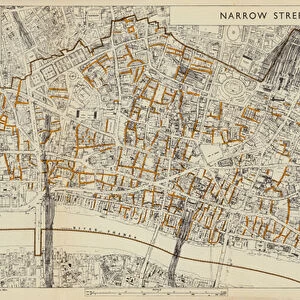
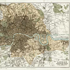
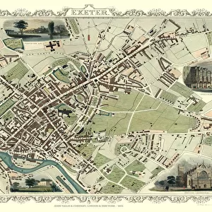
Old Map of London 1851 by John Tallis

![]()
Wall Art and Photo Gifts from MapSeeker
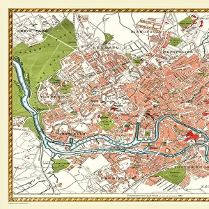
Old Map of London 1851 by John Tallis
Commemorating the Great Exhibition of Industry of All Nations 1851, this magnificent plan of London, re-created and art worked directly from the antique original, is elegantly framed by 49 individual views of Londons historic buildings and monuments. The plan is incredibly detailed considering the large area it captures. Surrounded by countryside, to the north - west is Cricklewood and Hampstead, to the north east is Lowe Leyton and Leyton Stowe. To the south west is Fulham and to the south east the Isle of Dogs and Greenwich. Among the many historic buildings and monuments illustrated are the Houses of Parliament, Westminster Abbey, St Pauls Cathedral, Tower of London, Buckingham Palace and the grand Crystal Palace built for the great exhibition of Industry of all nations held in London
Welcome to the Mapseeker Image library and enter an historic gateway to one of the largest on-line collections of Historic Maps, Nostalgic Views, Vista's and Panorama's from a World gone by.
Media ID 20348248
Historic Map John Tallis John Tallis Map London Map Map Of London Old Town Plan Tallis Map London City
FEATURES IN THESE COLLECTIONS
> Architecture
> Great Houses
> Buckingham Palace
> Architecture
> Towers
> Cathedrals
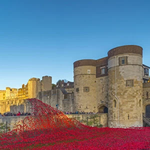
> Architecture
> Towers
> Tower of London
> Arts
> Artists
> T
> John Tallis
> Arts
> Photorealistic artworks
> Detailed art pieces
> Masterful detailing in art
> Europe
> United Kingdom
> England
> London
> Boroughs
> City of London
> Europe
> United Kingdom
> England
> London
> Boroughs
> City of Westminster
> Europe
> United Kingdom
> England
> London
> Boroughs
> Greenwich
> Europe
> United Kingdom
> England
> London
> Boroughs
> Hammersmith and Fulham
> MapSeeker
> British Town And City Plans
> English & Welsh PORTFOLIO
EDITORS COMMENTS
This beautifully preserved print showcases the "Old Map of London 1851" by John Tallis, a remarkable piece that commemorates the Great Exhibition of Industry of All Nations held in that same year. The map is an exquisite recreation and artwork directly sourced from the antique original, elegantly framed by 49 individual views depicting London's historic buildings and monuments. What makes this map truly exceptional is its incredible level of detail considering the vast area it encompasses. Stretching across the cityscape, one can observe surrounding countryside areas such as Cricklewood, Hampstead, Lowe Leyton, Leyton Stowe, Fulham to the southwest, and Isle of Dogs along with Greenwich to the southeast. Amongst these picturesque landscapes lie some of London's most iconic landmarks depicted on this historic map. From the majestic Houses of Parliament to Westminster Abbey and St Paul's Cathedral; from the imposing Tower of London to Buckingham Palace; and not forgetting the grand Crystal Palace constructed specifically for hosting the Great Exhibition itself. This print offers a glimpse into Victorian-era London while paying homage to its rich architectural heritage. It serves as a testament to John Tallis' artistic prowess in capturing both intricate details and grandeur within a single masterpiece. A true treasure for history enthusiasts or anyone seeking an enchanting visual journey through time in our beloved capital city.
MADE IN THE USA
Safe Shipping with 30 Day Money Back Guarantee
FREE PERSONALISATION*
We are proud to offer a range of customisation features including Personalised Captions, Color Filters and Picture Zoom Tools
SECURE PAYMENTS
We happily accept a wide range of payment options so you can pay for the things you need in the way that is most convenient for you
* Options may vary by product and licensing agreement. Zoomed Pictures can be adjusted in the Cart.