Home > Arts > Artists > W > Robert Walker
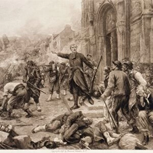
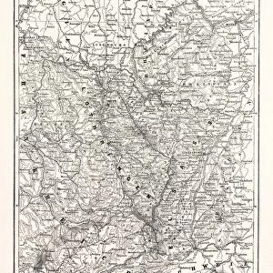
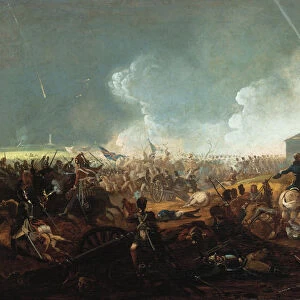
Map of the Battle of Beaumont, 30 August 1870, (c1872). Creator: R. Walker
. Creator: R. Walker")
![]()
Wall Art and Photo Gifts from Heritage Images
Map of the Battle of Beaumont, 30 August 1870, (c1872). Creator: R. Walker
Map of the Battle of Beaumont, 30 August 1870, (c1872). Map: Drawn under the Superintendance of Captain Hozier, showing the enemy positions. The Battle of Beaumont was fought near Beaumont-en-Argonne in northern France. From " The Franco-Prussian War: its causes, incidents and consequences", Volume I, by Captain H M Hozier. [William Mackenzie, London, 1872]
Heritage Images features heritage image collections
Media ID 19778667
© The Print Collector/Heritage Images
1870 1871 Adversary Argonne Bamp W Border Enemy Franco Prussian War Front Line Frontier Frontline H M Hozier Henry Montague Henry Montague Hozier Hozier Lines Mackenzie Meuse Prussia Prussian Prussian Army R Walker River Maas River Meuse Robert Walker Sir Henry Montagu Hozier Walker William Mackenzie Battlefield
FEATURES IN THESE COLLECTIONS
> Arts
> Artists
> W
> Robert Walker
> Arts
> Artists
> W
> Robert White
> Arts
> Artists
> W
> William White
> Arts
> Landscape paintings
> Forest and woodland scenes
> Forest artwork
> Arts
> Landscape paintings
> Waterfall and river artworks
> River artworks
> Europe
> France
> Canton
> Meuse
> Historic
> Battles
> Related Images
EDITORS COMMENTS
This print showcases the "Map of the Battle of Beaumont, 30 August 1870" drawn under the supervision of Captain Hozier. The intricate details depicted in this map provide a glimpse into the enemy positions during one of the significant battles fought near Beaumont-en-Argonne in northern France. The image transports us back to the 19th century, immersing us in a world where armed forces strategized and battled for control. The forested landscape, marked by a meandering river, sets the stage for intense warfare that unfolded on these very grounds. It serves as a reminder of how geography played an essential role in shaping military tactics and outcomes. As we study this historical artifact, it becomes evident that every line and symbol represents not only physical boundaries but also human lives at stake. This map offers valuable insights into the Franco-Prussian War's complexities – its causes, incidents, and consequences – as documented by Captain H M Hozier. Preserved within these lines are tales of bravery and sacrifice from both sides: French adversaries defending their homeland against Prussian forces seeking to expand their influence. Through this photo print, we gain access to an invaluable resource that helps us understand how borders were contested and armies maneuvered during this tumultuous period. Thanks to Robert Walker's meticulous craftsmanship as creator and William Mackenzie's publication efforts in London (1872), we can now appreciate this piece of history with awe-inspiring clarity.
MADE IN THE USA
Safe Shipping with 30 Day Money Back Guarantee
FREE PERSONALISATION*
We are proud to offer a range of customisation features including Personalised Captions, Color Filters and Picture Zoom Tools
SECURE PAYMENTS
We happily accept a wide range of payment options so you can pay for the things you need in the way that is most convenient for you
* Options may vary by product and licensing agreement. Zoomed Pictures can be adjusted in the Cart.