Home > Europe > United Kingdom > England > London > Sights > Victoria Park
South Buckinghamshire SL2 5 Map

![]()
Wall Art and Photo Gifts from Map Marketing
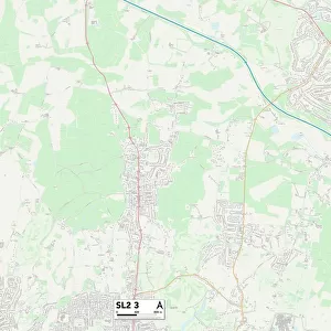
South Buckinghamshire SL2 5 Map
Postcode Sector Map of South Buckinghamshire SL2 5
Media ID 19978834
Albion Close Bell Close Benson Close Beresford Avenue Carlton Road Clarendon Court Dunbar Close Elmwood Road Fleetwood Road Grasmere Avenue Kendal Close Kendal Drive Malpas Road Maple Crescent Mill Street Moat Drive Montague Road Montgomery Place Muddy Lane Myrtle Crescent Preston Road Railway Terrace School Lane Slough South Buckinghamshire St Johns Road St Pauls Avenue Stewart Avenue Stoke Road The Link Troutbeck Close Uxbridge Road Victoria Road Stokesay
FEATURES IN THESE COLLECTIONS
> Arts
> Artists
> F
> John Field
> Arts
> Artists
> N
> John Norman
> Europe
> Norway
> Related Images
> Europe
> United Kingdom
> England
> Buckinghamshire
> Marlow
> Europe
> United Kingdom
> England
> Buckinghamshire
> Related Images
> Europe
> United Kingdom
> England
> London
> Sights
> Victoria Park
> Europe
> United Kingdom
> Scotland
> Dumfries and Galloway
> Related Images
> Map Marketing
> Postcode Sector Maps
> SL - Slough
MADE IN THE USA
Safe Shipping with 30 Day Money Back Guarantee
FREE PERSONALISATION*
We are proud to offer a range of customisation features including Personalised Captions, Color Filters and Picture Zoom Tools
SECURE PAYMENTS
We happily accept a wide range of payment options so you can pay for the things you need in the way that is most convenient for you
* Options may vary by product and licensing agreement. Zoomed Pictures can be adjusted in the Cart.