Home > Europe > United Kingdom > England > London > Boroughs > Greenwich
Whole Earth at night, satellite image

![]()
Wall Art and Photo Gifts from Science Photo Library
Whole Earth at night, satellite image
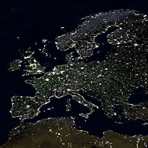
Whole Earth at night, satellite image. This map is centred on the Greenwich meridian, at zero degrees latitude. City lights (yellow) show areas of dense population, and areas of few lights are more sparsely populated. This image was produced by combining data from the Defense Meteorological Satellite Program (DMSP) and NOas POES satellites
Science Photo Library features Science and Medical images including photos and illustrations
Media ID 1705105
© PLANETARY VISIONS LTD/SCIENCE PHOTO LIBRARY
Artificial Lighting Cities City Combined Data Continent Continents Dark Darkness Defense Meteorological Demographics Demography Densely Populated Density Distribution Dmsp Earth Observation Earth Science Energy Environmental Impact From Space Globe Hemisphere Human Geography Human Population Inhabited Light Light Pollution Lights Night Night Time Noaa Poes Polar Orbiter Populated Population Power Satellite Satellite Image Satellite Program Sparsely Populated Uninhabited Urban Urban Geography Urbanisation Urbanised Urbanization Urbanized Whole Earth World
FEATURES IN THESE COLLECTIONS
> Animals
> Mammals
> Cats (Wild)
> Populator
> Europe
> United Kingdom
> England
> London
> Boroughs
> Greenwich
> Maps and Charts
> Related Images
> Maps and Charts
> World
> Science Photo Library
> Aerial and Satellite
> Science
> Space Exploration
> Planets
> Earth
EDITORS COMMENTS
This print showcases the mesmerizing beauty of our planet at night. Taken from a satellite, this image presents the Whole Earth illuminated by city lights, revealing areas of dense population in vibrant yellow hues and more sparsely populated regions with fewer lights. The map is centered on the Greenwich meridian, marking zero degrees latitude. The creation of this remarkable image involved combining data from two satellites: the Defense Meteorological Satellite Program (DMSP) and NOAA's POES satellites. These technological marvels captured the essence of our world's urbanization and human geography, shedding light on population distribution across continents. As we gaze upon this photograph, it becomes evident how artificial lighting has transformed our planet during nighttime. While cities shine brightly as beacons of energy and progress, uninhabited areas remain enveloped in darkness. This stark contrast highlights both the power and environmental impact of human civilization. Beyond its aesthetic appeal, this image raises awareness about light pollution and its consequences for ecosystems worldwide. It serves as a reminder that even from space, we can witness humanity's imprint on Earth's surface. Through advancements in earth observation technology like these satellites provide us with invaluable insights into demographics and urban geography in the 21st century. As we continue to navigate an increasingly urbanized world, understanding these patterns becomes crucial for sustainable development and preserving our delicate environment. Photo credit: Science Photo Library
MADE IN THE USA
Safe Shipping with 30 Day Money Back Guarantee
FREE PERSONALISATION*
We are proud to offer a range of customisation features including Personalised Captions, Color Filters and Picture Zoom Tools
SECURE PAYMENTS
We happily accept a wide range of payment options so you can pay for the things you need in the way that is most convenient for you
* Options may vary by product and licensing agreement. Zoomed Pictures can be adjusted in the Cart.