Home > Arts > Artists > O > Abraham Ortelius
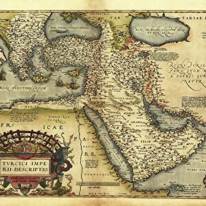
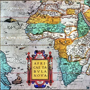
Map of Germany and current Netherlands. Theatrum Orbis Terra

![]()
Wall Art and Photo Gifts from Mary Evans Picture Library
Map of Germany and current Netherlands. Theatrum Orbis Terra
Map of Germany and current Netherlands. Theatrum Orbis Terrarum by Abraham Ortelius (1527-1598). First Edition. Antwerp, 1574. Library of Catalonia. Barcelona. Spain
Mary Evans Picture Library makes available wonderful images created for people to enjoy over the centuries
Media ID 14333261
© Thaliastock / Mary Evans
1574 Abraham Antwerp Atlas Carthography Cartographic Cartography Catalonia Continent Descriptio Edition Flanders Flemish Geography Netherlands Orbis Ortelius Ortels Terrarum Theatrum
FEATURES IN THESE COLLECTIONS
> Animals
> Mammals
> Muridae
> Water Mouse
> Arts
> Artists
> O
> Abraham Ortelius
> Europe
> Belgium
> Related Images
> Europe
> Germany
> Related Images
> Maps and Charts
> Abraham Ortelius
EDITORS COMMENTS
This image showcases a rare and historically significant map print of Germany and the current Netherlands, as depicted in Theatrum Orbis Terrarum, the first modern atlas, created by the renowned Flemish cartographer Abraham Ortelius in 1574. The map, which is housed in the Library of Catalonia in Barcelona, Spain, offers a fascinating glimpse into the geographical knowledge of the late 16th century. Ortelius, a native of Antwerp, Belgium, was a pioneering figure in the field of cartography during the European Age of Discovery. His groundbreaking atlas, Theatrum Orbis Terrarum, was the first to present a uniform and consistent set of maps based on the latest geographical discoveries and research. The map of Germany and the Netherlands in this first edition is a testament to the meticulous detail and accuracy of Ortelius' work. The map reveals the political and geographical landscape of central Europe during the late 16th century, with the Holy Roman Empire of the German Nation dominating the map, and the southern part of what is now the Netherlands depicted as the Spanish Netherlands. The intricate detail of the map includes the names of various rivers, mountains, and cities, as well as the depiction of several ships and a vessel in the North Sea, reflecting the importance of maritime trade during this period. The map also bears the title "Descriptio Germaniae Inferioris," which translates to "Description of Lower Germany," highlighting the regional divisions and political complexities of the time. The map's title in Latin, "Theatrum Orbis Terrarum," meaning "The Theatre of the World," underscores the importance of geographical knowledge and exploration during the era of European expansion and discovery. This exquisite map print is a valuable historical artifact, offering a unique window into the geographical and political landscape of Europe during the late 16th century.
MADE IN THE USA
Safe Shipping with 30 Day Money Back Guarantee
FREE PERSONALISATION*
We are proud to offer a range of customisation features including Personalised Captions, Color Filters and Picture Zoom Tools
SECURE PAYMENTS
We happily accept a wide range of payment options so you can pay for the things you need in the way that is most convenient for you
* Options may vary by product and licensing agreement. Zoomed Pictures can be adjusted in the Cart.