Home > Europe > United Kingdom > England > London > Politics > Neville Chamberlain
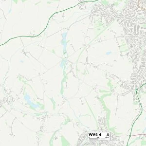
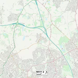
Wolverhampton WV4 5 Map

![]()
Wall Art and Photo Gifts from Map Marketing
Wolverhampton WV4 5 Map
Postcode Sector Map of Wolverhampton WV4 5
Media ID 19983330
Alexandra Road Ascot Drive Ashwood Grove Balmoral Road Belmont Road Belvedere Avenue Birchwood Road Buckingham Road Butts Road Charles Avenue Church Hill Coton Road Elizabeth Avenue Fairlawns Holden Road Hornby Road Links Road Manor Close Manor Road Mount Road Neville Avenue Orchard Grove Park Avenue Park Drive Park Hall Road Ridgeway Drive Rosemary Crescent Ryecroft Avenue Sandhurst Drive Sandringham Road Squirrel Walk Stourbridge Road Sutherland Road The Avenue The Fold Vicarage Road Virginia Drive Ward Road Westbourne Road Westminster Avenue Whitehall Road Wolverhampton
FEATURES IN THESE COLLECTIONS
> Animals
> Mammals
> Squirrel
> Europe
> United Kingdom
> England
> London
> Boroughs
> Bromley
> Europe
> United Kingdom
> England
> London
> Politics
> Neville Chamberlain
> Europe
> United Kingdom
> Scotland
> Sutherland
> Map Marketing
> Postcode Sector Maps
> WV - Wolverhampton
> Maps and Charts
> Related Images
MADE IN THE USA
Safe Shipping with 30 Day Money Back Guarantee
FREE PERSONALISATION*
We are proud to offer a range of customisation features including Personalised Captions, Color Filters and Picture Zoom Tools
SECURE PAYMENTS
We happily accept a wide range of payment options so you can pay for the things you need in the way that is most convenient for you
* Options may vary by product and licensing agreement. Zoomed Pictures can be adjusted in the Cart.