Home > Europe > United Kingdom > England > Kent > Green Street Green
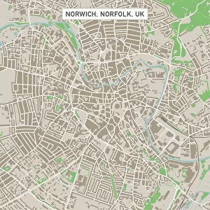
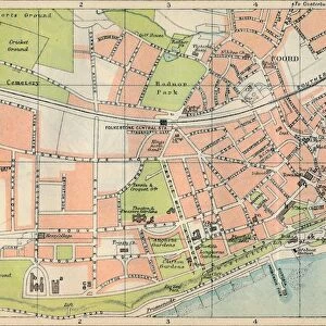
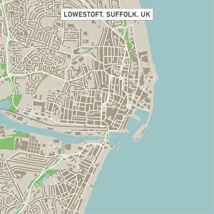
Folkestone Kent UK City Street Map

![]()
Wall Art and Photo Gifts from Fine Art Storehouse
Folkestone Kent UK City Street Map
Vector Illustration of a City Street Map of Folkestone, Kent, UK. Included files are EPS (v10) and Hi-Res JPG.
Data courtesy from Ordnance Survey: VectorMap District
https:/ordnancesurvey.co.uk/business-and-government/products/vectormap-district.html
OS OpenData is free to use under the Open Government Licence (OGL).
Contains OS data eCrown copyright and database right 2017.
http:/nationalarchives.gov.uk/doc/open-government-licence/version/3/
Unleash your creativity and transform your space into a visual masterpiece!
Frank Ramspott
Media ID 15055219
© Frank Ramspott, all rights reserved
Aerial View Computer Graphic Directly Above Gray Green Harbor Kent North Sea Road Map Street Map Text Digitally Generated Image Folkestone
FEATURES IN THESE COLLECTIONS
> Aerial Photography
> Related Images
> Arts
> Contemporary art
> Digital artwork
> Street art
> Arts
> Portraits
> Pop art gallery
> Street art portraits
> Arts
> Street art graffiti
> Digital art
> Digital paintings
> Arts
> Street art graffiti
> Digital art
> Vector illustrations
> Europe
> United Kingdom
> England
> Kent
> Folkestone
> Europe
> United Kingdom
> England
> Kent
> Green Street Green
> Europe
> United Kingdom
> England
> Kent
> Kent Street
> Europe
> United Kingdom
> England
> Kent
> North Street
> Europe
> United Kingdom
> Maps
> Fine Art Storehouse
> Map
> Street Maps
EDITORS COMMENTS
This print showcases a meticulously detailed vector illustration of the charming city street map of Folkestone, Kent in the United Kingdom. With its vibrant colors and intricate design, this artwork brings to life the essence of this coastal town. The inclusion of files in EPS (v10) and Hi-Res JPG formats ensures versatility for various applications. The accuracy and precision of this map are made possible by data courtesy from Ordnance Survey: VectorMap District, a trusted source known for its comprehensive mapping solutions. It is worth noting that OS OpenData used in creating this masterpiece is freely available under the Open Government Licence (OGL), reflecting a commitment to open access and transparency. From its picturesque harbor to the stunning coastline along the North Sea, every aspect of Folkestone's geography is beautifully captured in this digitally generated image. The absence of people allows viewers to focus solely on appreciating the architectural marvels that dot these streets. With an aerial view directly above, one can admire how seamlessly roads intertwine with buildings, forming a tapestry unique to this city. The color palette consisting of gray, green, blue, and white adds depth and visual appeal to this exceptional cartographic creation by Frank Ramspott. Whether you are an admirer of maps or simply seeking a piece that celebrates your connection to Folkestone or Kent as a whole, this print effortlessly combines artistry with functionality—a true testament to fine craftsmanship available at Fine Art Storehouse.
MADE IN THE USA
Safe Shipping with 30 Day Money Back Guarantee
FREE PERSONALISATION*
We are proud to offer a range of customisation features including Personalised Captions, Color Filters and Picture Zoom Tools
SECURE PAYMENTS
We happily accept a wide range of payment options so you can pay for the things you need in the way that is most convenient for you
* Options may vary by product and licensing agreement. Zoomed Pictures can be adjusted in the Cart.