Home > North America > United States of America > New York > New York > Sights > New York Public Library
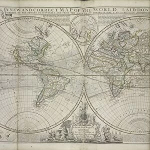
A new and correct map of the world laid down according to the newest discoveries

![]()
Wall Art and Photo Gifts from Fine Art Finder
A new and correct map of the world laid down according to the newest discoveries
XOS1765728 A new and correct map of the world laid down according to the newest discoveries and from the most exact observations, 1736 (hand coloured print) by Moll, Hermann (fl.1678-1732); 64x101 cm; New York Public Library, USA; (add.info.: Dedicated to George II.); German, out of copyright
Media ID 12742651
© www.bridgemanimages.com
Atlas Celestial Globe Hemispheres Hydrography Latitude Longitude Navigation Planets Sea Chart Shipping Terrestrial World Map
FEATURES IN THESE COLLECTIONS
> Arts
> Artists
> O
> Oceanic Oceanic
> Europe
> Germany
> Related Images
> Fine Art Finder
> Artists
> Hermann Moll
> Maps and Charts
> World
> North America
> United States of America
> Maps
> North America
> United States of America
> New York
> New York
> Maps
> North America
> United States of America
> New York
> New York
> Sights
> New York Public Library
EDITORS COMMENTS
This hand-colored print titled "A new and correct map of the world laid down according to the newest discoveries and from the most exact observations" showcases Hermann Moll's exceptional cartographic skills. Created in 1736, this masterpiece measures 64x101 cm and is currently housed at the New York Public Library in the USA. Dedicated to George II, this meticulously detailed map transports us back to an era of exploration and maritime adventure. With its intricate depiction of coastlines, hydrography, sea charts, and celestial bodies, it offers a comprehensive view of our planet during that time. The vibrant colors bring life to continents like America while highlighting shipping routes across vast oceans. This visual representation not only serves as a navigational tool but also sparks curiosity about distant lands waiting to be discovered. Moll's expertise shines through as he accurately portrays longitude and latitude lines, allowing sailors to navigate with precision. The inclusion of planets adds an element of wonderment, reminding viewers that Earth is just one piece within a vast universe waiting for further exploration. As we gaze upon this historic artifact from centuries past, we are reminded of humanity's insatiable thirst for knowledge and discovery. It stands as a testament to mankind's relentless pursuit of understanding our world – both terrestrial and celestial – through meticulous cartography.
MADE IN THE USA
Safe Shipping with 30 Day Money Back Guarantee
FREE PERSONALISATION*
We are proud to offer a range of customisation features including Personalised Captions, Color Filters and Picture Zoom Tools
SECURE PAYMENTS
We happily accept a wide range of payment options so you can pay for the things you need in the way that is most convenient for you
* Options may vary by product and licensing agreement. Zoomed Pictures can be adjusted in the Cart.