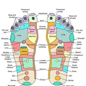
Home > Europe > United Kingdom > England > London > Towns > Welling
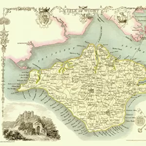
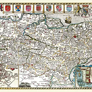
Old County Map of Northamptonshire 1836 by Thomas Moule

![]()
Wall Art and Photo Gifts from MapSeeker
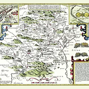
Old County Map of Northamptonshire 1836 by Thomas Moule
This is a fine decorative reproduction County Map of Northamptonshire from the First Edition series of Thomas Moule Maps, originally Published in 1836. The well-known series of County Maps which are known as Moules feature beautiful vignette views and were first published in separate sections for each county in 1830-32, they were then published in collected form in a two-volume work: The English Counties Delineated: or a Topographical Description of England: Illustrated by a Complete Series of County Maps by Thomas Moule: London: Published by George Virtue 1836
Welcome to the Mapseeker Image library and enter an historic gateway to one of the largest on-line collections of Historic Maps, Nostalgic Views, Vista's and Panorama's from a World gone by.
Media ID 20347923
© Mapseeker Publishing Ltd
County Map County Map Of England English County Map Historic Map Moule Map Old County Map Old English County Map Old Moule Map Thomas Moule Thomas Moule Map Northamptonshire
FEATURES IN THESE COLLECTIONS
> Arts
> Artists
> M
> Thomas Moule
> Europe
> United Kingdom
> England
> London
> Towns
> Welling
> Europe
> United Kingdom
> England
> Maps
> Europe
> United Kingdom
> England
> Northamptonshire
> Old
> Europe
> United Kingdom
> England
> Northamptonshire
> Related Images
> Europe
> United Kingdom
> England
> Wells
> Maps and Charts
> Early Maps
> Maps and Charts
> Related Images
> MapSeeker
> Maps from the British Isles
> England and Counties PORTFOLIO
EDITORS COMMENTS
This exquisite print showcases the "Old County Map of Northamptonshire 1836" by Thomas Moule, a renowned cartographer of his time. Originally published as part of Moule's First Edition series in 1836, this decorative reproduction offers a glimpse into the historical geography of Northamptonshire. Moule's county maps were highly regarded for their intricate details and artistic vignette views. The map was initially released in sections between 1830 and 1832 before being compiled into a two-volume work titled "The English Counties Delineated: or a Topographical Description of England: Illustrated by a Complete Series of County Maps". This particular edition was published by George Virtue in London in 1836. As you explore this piece, you'll be transported back to an era when cartography was not only functional but also aesthetically pleasing. The old English county map depicts Northamptonshire with precision, highlighting its towns, villages, rivers, and roads. It serves as both an educational tool and a beautiful decoration for any history enthusiast or lover of vintage art. With its rich historical significance and meticulous craftsmanship, this historic map is truly a treasure worth cherishing. Whether you're fascinated by the history of Northamptonshire or simply appreciate the beauty found within antique maps, this print allows you to own a piece of Thomas Moule's legacy while adding an elegant touch to your surroundings.
MADE IN THE USA
Safe Shipping with 30 Day Money Back Guarantee
FREE PERSONALISATION*
We are proud to offer a range of customisation features including Personalised Captions, Color Filters and Picture Zoom Tools
SECURE PAYMENTS
We happily accept a wide range of payment options so you can pay for the things you need in the way that is most convenient for you
* Options may vary by product and licensing agreement. Zoomed Pictures can be adjusted in the Cart.