Home > Europe > United Kingdom > England > London > Politics > Frederick North
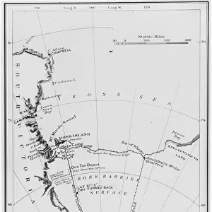
Western Franz Josef Land, 1899

![]()
Wall Art and Photo Gifts from Heritage Images
Western Franz Josef Land, 1899
Western Franz Josef Land, 1899. Map showing discoveries and sledge journeys from 1894 to 1897. From an account of the Jackson-Harmsworth Expedition to Franz-Josef Land in the Arctic. The three-year expedition established that Franz Josef Land was in fact a small archipelago rather than a land mass that extended to the North Pole, as its leader, Frederick George Jackson, had believed. A print from A Thousand Days in the Arctic, by Frederick G Jackson, Volume II, Harper & Brothers, London, 1899
Heritage Images features heritage image collections
Media ID 14955600
© The Print Collector / Heritage-Images
Archipelago Arctic Cartography Discovery Expedition Exploration Frederick George Frederick George Jackson Frederick Jackson Island Jackson Journey Map Making Polar Rossiya Route Archangelsk Franz Josef Land Jackson Harmsworth Expedition
FEATURES IN THESE COLLECTIONS
> Animals
> Mammals
> Muridae
> Western Mouse
> Europe
> France
> Canton
> Landes
> Europe
> Russia
> Related Images
> Europe
> United Kingdom
> England
> London
> Politics
> Frederick North
> Maps and Charts
> Related Images
> Popular Themes
> North Island
> Popular Themes
> Russian Leaders
EDITORS COMMENTS
This print captures the Western Franz Josef Land in 1899, showcasing a map that reveals the remarkable discoveries and sledge journeys made between 1894 and 1897. The image is derived from an account of the Jackson-Harmsworth Expedition to Franz-Josef Land in the Arctic, led by Frederick George Jackson. This three-year expedition shattered previous beliefs held by Jackson himself, as it established that Franz Josef Land was not a vast land mass extending all the way to the North Pole but rather a small archipelago. The print, extracted from "A Thousand Days in the Arctic" by Frederick G. Jackson, Volume II (published by Harper & Brothers, London), offers us a glimpse into this extraordinary journey of travel and exploration during Victorian times. It showcases how British explorers ventured into uncharted territories with great determination and curiosity. With its vibrant colors and intricate details, this historical artifact takes us back to the 19th century when cartography played a crucial role in unraveling geographical mysteries. It symbolizes both Russia's influence on these remote lands through Archangelsk and Britain's ambitious spirit of discovery. As we gaze upon this print, we are reminded of humanity's relentless pursuit of knowledge about our planet's most remote corners—a testament to human resilience and our insatiable desire for exploration.
MADE IN THE USA
Safe Shipping with 30 Day Money Back Guarantee
FREE PERSONALISATION*
We are proud to offer a range of customisation features including Personalised Captions, Color Filters and Picture Zoom Tools
SECURE PAYMENTS
We happily accept a wide range of payment options so you can pay for the things you need in the way that is most convenient for you
* Options may vary by product and licensing agreement. Zoomed Pictures can be adjusted in the Cart.