Home > Europe > United Kingdom > England > London > Towns > Lambeth
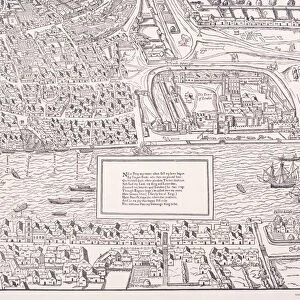
Maps of England, Wales and London, 1718

![]()
Wall Art and Photo Gifts from Heritage Images
Maps of England, Wales and London, 1718
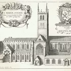
Maps of England, Wales and London, 1718. A map of England, Wales and part of Scotland is placed between two groups of allegorical figures. Below this is a map of the City of London, City of Westminster, the River Thames, Lambeth, Southwark and surrounding areas. The lower section contains text
Heritage Images features heritage image collections
Media ID 15175430
© London Metropolitan Archives (City of London) / Heritage-Images
Cartography Lambeth Map Making Southwark Wales Allegorical Figure City Of Westminster
FEATURES IN THESE COLLECTIONS
> Arts
> Minimalist artwork
> Monochrome artwork
> Fine art
> Arts
> Minimalist artwork
> Monochrome artwork
> Monochrome paintings
> Europe
> United Kingdom
> England
> London
> Boroughs
> City of London
> Europe
> United Kingdom
> England
> London
> Boroughs
> City of Westminster
> Europe
> United Kingdom
> England
> London
> Boroughs
> Lambeth
> Europe
> United Kingdom
> England
> London
> Boroughs
> Southwark
> Europe
> United Kingdom
> England
> London
> Museums
> British Library
> Europe
> United Kingdom
> England
> London
> River Thames
> Europe
> United Kingdom
> England
> London
> Towns
> Lambeth
> Europe
> United Kingdom
> England
> Maps
EDITORS COMMENTS
This print takes us back to the year 1718, immersing us in the rich history of England, Wales, and London. The image showcases a meticulously crafted map that depicts these regions alongside an array of allegorical figures. Placed between two groups of these symbolic representations, the map offers a glimpse into the geography and topography of England, Wales, and even part of Scotland. Beneath this grand display lies another intricate map that focuses specifically on the City of London, City of Westminster, Lambeth, Southwark, and their surrounding areas. This detailed rendering allows viewers to explore the streets and landmarks that have shaped one of the world's most iconic cities. The monochrome aesthetic adds a sense of nostalgia to this 18th-century engraving while emphasizing its historical significance. As we delve into each stroke on this print created by an anonymous artist from Britain's past centuries ago, we are transported through time. Preserved within Guildhall Library and Art Gallery today is this remarkable piece which not only serves as a testament to English cartography but also stands as a tribute to our ancestors' dedication in mapping out their country with precision. Let us cherish this extraordinary snapshot from history for its artistic beauty as well as its invaluable contribution to our understanding of geographical features during that era - all captured within one stunning image.
MADE IN THE USA
Safe Shipping with 30 Day Money Back Guarantee
FREE PERSONALISATION*
We are proud to offer a range of customisation features including Personalised Captions, Color Filters and Picture Zoom Tools
SECURE PAYMENTS
We happily accept a wide range of payment options so you can pay for the things you need in the way that is most convenient for you
* Options may vary by product and licensing agreement. Zoomed Pictures can be adjusted in the Cart.