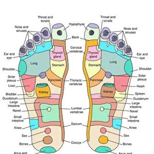
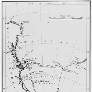
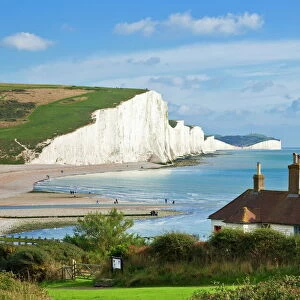
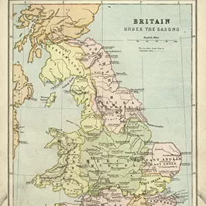
Home > Europe > United Kingdom > England > Sussex > South Bersted
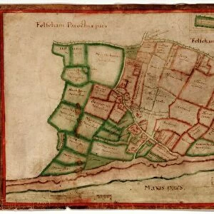
Felpham tithe map, c. 1844

![]()
Wall Art and Photo Gifts from West Sussex County Council
Felpham tithe map, c. 1844
No date, but Award 1844. By Thomas Wisdom, South Bersted. 26.6 in. to 1m. 70 × 60
Tithe Award Map Collection
West Sussex Record Office Ref No: TD/W54
West Sussex County Council Record Office contains a fascinating history of the county of West Sussex, England
Media ID 10716323
© West Sussex County Council - All Rights Reserved
1840s 19th Century Historical Mapping South Of England
FEATURES IN THESE COLLECTIONS
> Europe
> United Kingdom
> England
> Maps
> Europe
> United Kingdom
> England
> Sussex
> Felpham
> Europe
> United Kingdom
> England
> Sussex
> Related Images
> Europe
> United Kingdom
> England
> Sussex
> South Bersted
> Europe
> United Kingdom
> England
> West Sussex
> Related Images
> Maps and Charts
> Early Maps
> Maps and Charts
> Related Images
> West Sussex County Council
> West Sussex Record Office
> Tithe Award Maps, 1808-1859
EDITORS COMMENTS
This print showcases the Felpham tithe map, a remarkable piece of historical mapping dating back to the 19th century. Created by Thomas Wisdom from South Bersted in approximately 1844, this meticulously detailed map offers a fascinating glimpse into the past. Measuring an impressive 26.6 inches to 1 meter and spanning across an area of 70 by 60, it provides valuable insights into land ownership and usage during that era. The Tithe Award Map Collection at West Sussex Record Office proudly houses this significant artifact, which holds immense historical value for researchers and enthusiasts alike. With its intricate cartography and meticulous attention to detail, this map serves as a testament to the craftsmanship of its creator. Located in the south of England, Felpham is brought to life through this extraordinary visual representation. The map not only reveals the landscape's physical features but also sheds light on how land was divided among different owners during that time period. Preserved by West Sussex County Council, this print allows us to appreciate and study our rich heritage without commercial use intentions. It stands as a reminder of our collective history and invites us to explore the stories hidden within its carefully drawn boundaries.
MADE IN THE USA
Safe Shipping with 30 Day Money Back Guarantee
FREE PERSONALISATION*
We are proud to offer a range of customisation features including Personalised Captions, Color Filters and Picture Zoom Tools
SECURE PAYMENTS
We happily accept a wide range of payment options so you can pay for the things you need in the way that is most convenient for you
* Options may vary by product and licensing agreement. Zoomed Pictures can be adjusted in the Cart.