Home > Architecture > Towers > Churches
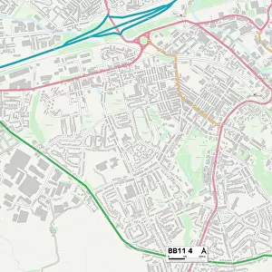
Thurrock RM17 6 Map

![]()
Wall Art and Photo Gifts from Map Marketing
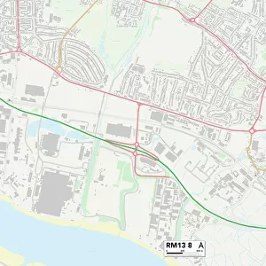
Thurrock RM17 6 Map
Postcode Sector Map of Thurrock RM17 6
Media ID 19977814
Alfred Street Arthur Street Bedford Road Benson Road Blackmore Road Bond Street Bridge Road Broadway Bromley Charles Street Cherry Tree Close Church Street Churchill Road Clarence Road Conway Gardens Crescent Avenue Crown Road Darnley Road Dock Road Elm Road Exmouth Road Falcon Avenue Finchley Road George Street Gipsy Lane Grange Road Grove Road Hastings Close Henry Street High Street John Street Kent Road Lewes Close Manor Road Manor Way Maple Road Medina Road New Road Oak Road Park Road Percy Street Prospect Place Rectory Road Richmond Road Rookery Lane Rosedale Road Salisbury Road St Leonards Close St Marys Close Stanley Road Station Approach Thames Road The Retreat The Willows Thurrock Towers Road West Street Whitehall Lane William Street Wood Street Astley Goldsmith Grays
FEATURES IN THESE COLLECTIONS
> Architecture
> Towers
> Churches
> Architecture
> Towers
> Tower Bridge
> Arts
> Artists
> B
> Charles Bruce
> Arts
> Artists
> B
> John Bromley
> Arts
> Artists
> B
> William Bromley
> Arts
> Artists
> C
> William Charles
> Arts
> Artists
> D
> Alfred
> Related Images
> Arts
> Artists
> D
> William Derby
> Arts
> Artists
> E
> Alfred East
> Arts
> Artists
> R
> George Richmond
> Map Marketing
> Postcode Sector Maps
> RM - Romford
MADE IN THE USA
Safe Shipping with 30 Day Money Back Guarantee
FREE PERSONALISATION*
We are proud to offer a range of customisation features including Personalised Captions, Color Filters and Picture Zoom Tools
SECURE PAYMENTS
We happily accept a wide range of payment options so you can pay for the things you need in the way that is most convenient for you
* Options may vary by product and licensing agreement. Zoomed Pictures can be adjusted in the Cart.