Home > Aerial Photography > Related Images
Salem Oregon US City Street Map

![]()
Wall Art and Photo Gifts from Fine Art Storehouse
Salem Oregon US City Street Map
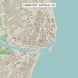
Vector Illustration of a City Street Map of Salem, Oregon, USA. Scale 1:60, 000.
All source data is in the public domain.
U.S. Geological Survey, US Topo
Used Layers:
USGS The National Map: National Hydrography Dataset (NHD)
USGS The National Map: National Transportation Dataset (NTD)
Unleash your creativity and transform your space into a visual masterpiece!
Frank Ramspott
Media ID 15055003
© Frank Ramspott, all rights reserved
Aerial View City Map Computer Graphic Directly Above Downtown District Gray Oregon Road Map Text Willamette River Digitally Generated Image Salem White Color
FEATURES IN THESE COLLECTIONS
> Aerial Photography
> Related Images
> Arts
> Contemporary art
> Digital artwork
> Street art
> Arts
> Landscape paintings
> Waterfall and river artworks
> River artworks
> Arts
> Portraits
> Pop art gallery
> Street art portraits
> Arts
> Street art graffiti
> Digital art
> Digital paintings
> Arts
> Street art graffiti
> Digital art
> Vector illustrations
> Fine Art Storehouse
> Map
> Street Maps
> Fine Art Storehouse
> Map
> USA Maps
> Maps and Charts
> Geological Map
> Maps and Charts
> Related Images
> North America
> United States of America
> Lakes
> Related Images
> North America
> United States of America
> Maps
EDITORS COMMENTS
This print showcases a meticulously detailed vector illustration of Salem, Oregon's city street map. With a scale of 1:60,000, every intricate aspect of the city is beautifully depicted in this artwork. The artist, Frank Ramspott, has utilized various layers from public domain sources such as the U. S. Geological Survey and US Topo to create this stunning piece. The map encompasses key features like the Willamette River that gracefully winds through the city and adds an element of serenity to its urban landscape. The downtown district stands out prominently with its bustling streets and vibrant energy. Surrounding areas are also highlighted, including lakes and rivers that contribute to Salem's natural beauty. Rendered in shades of gray, blue, and white colors against a texturized background, this digitally generated image offers an aerial view directly above Salem. Its cartographic design showcases the meticulous attention to detail put into creating this visually striking representation. Perfect for geography enthusiasts or those with a connection to Salem itself, this print brings together artistry and functionality seamlessly. It serves as both an aesthetically pleasing piece for display purposes while also providing valuable information about the city's layout and road networks.
MADE IN THE USA
Safe Shipping with 30 Day Money Back Guarantee
FREE PERSONALISATION*
We are proud to offer a range of customisation features including Personalised Captions, Color Filters and Picture Zoom Tools
SECURE PAYMENTS
We happily accept a wide range of payment options so you can pay for the things you need in the way that is most convenient for you
* Options may vary by product and licensing agreement. Zoomed Pictures can be adjusted in the Cart.