Home > Aerial Photography > America
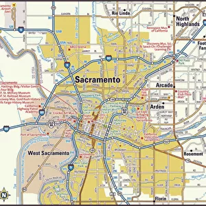
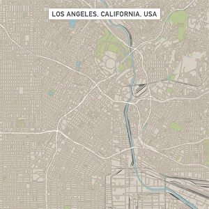
Sacramento California US City Street Map

![]()
Wall Art and Photo Gifts from Fine Art Storehouse
Sacramento California US City Street Map
Vector Illustration of a City Street Map of Sacramento, California, USA. Scale 1:60, 000.
All source data is in the public domain.
U.S. Geological Survey, US Topo
Used Layers:
USGS The National Map: National Hydrography Dataset (NHD)
USGS The National Map: National Transportation Dataset (NTD)
Unleash your creativity and transform your space into a visual masterpiece!
Frank Ramspott
Media ID 15055165
© Frank Ramspott, all rights reserved
Aerial View Blue Color California Computer Graphic Directly Above Downtown Gray Color Road Map Sacramento Street Map Text American River Digitally Generated Image Green Color Sacramento River White Color
FEATURES IN THESE COLLECTIONS
> Aerial Photography
> America
> Aerial Photography
> Related Images
> Animals
> Insects
> Hemiptera
> Green Scale
> Animals
> Mammals
> Cricetidae
> California Mouse
> Arts
> Contemporary art
> Digital artwork
> Street art
> Arts
> Landscape paintings
> Waterfall and river artworks
> River artworks
> Arts
> Portraits
> Pop art gallery
> Street art portraits
> Arts
> Street art graffiti
> Digital art
> Digital paintings
> Arts
> Street art graffiti
> Digital art
> Vector illustrations
> Fine Art Storehouse
> Map
> Street Maps
> Fine Art Storehouse
> Map
> USA Maps
EDITORS COMMENTS
This print showcases a meticulously detailed city street map of Sacramento, California, USA. With a scale of 1:60,000, every intricate feature is beautifully illustrated in this vector illustration. The source data used for this artwork is all from the public domain and includes USGS The National Map: National Hydrography Dataset (NHD) and USGS The National Map: National Transportation Dataset (NTD). The image highlights various elements that define Sacramento's urban landscape such as the bustling downtown area, the meandering Sacramento River and American River, lakes, buildings, streets, roads - all intricately woven together to form this vibrant city. This digitally generated image portrays an aerial view directly above the cityscape. The color palette employed in this design adds depth and clarity to the map; gray hues depict text while shades of green represent natural areas like parks or forests. Blue tones symbolize water bodies while white signifies open spaces or unmarked areas. Created by talented artist Frank Ramspott and available at Fine Art Storehouse, this visually stunning piece captures not only the physical geography but also the essence of Sacramento's charm. A perfect addition to any art collection or a thoughtful gift for those who appreciate cartography and urban landscapes alike.
MADE IN THE USA
Safe Shipping with 30 Day Money Back Guarantee
FREE PERSONALISATION*
We are proud to offer a range of customisation features including Personalised Captions, Color Filters and Picture Zoom Tools
SECURE PAYMENTS
We happily accept a wide range of payment options so you can pay for the things you need in the way that is most convenient for you
* Options may vary by product and licensing agreement. Zoomed Pictures can be adjusted in the Cart.