Home > Arts > Contemporary art > Digital artwork > Street art
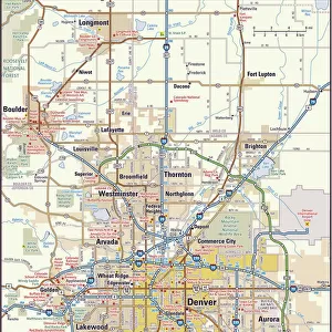
MA Franklin Shutesbury Vector Road Map

![]()
Wall Art and Photo Gifts from Fine Art Storehouse
MA Franklin Shutesbury Vector Road Map
MA Franklin Shutesbury Vector Road Map. All source data is in the public domain. U.S. Census Bureau Census Tiger. Used Layers: areawater, linearwater, roads, rails, cousub, pointlm, uac10
Unleash your creativity and transform your space into a visual masterpiece!
Frank Ramspott
Media ID 20689785
© Frank Ramspott, all rights reserved
City Map Computer Graphic County Digital Composite District Franklin Geographical Border Massachusetts Road Map Text Vector Cushman Digitally Generated Image
FEATURES IN THESE COLLECTIONS
> Animals
> Mammals
> Cats (Wild)
> Tiger
> Animals
> Mammals
> Muridae
> Water Mouse
> Arts
> Contemporary art
> Digital artwork
> Street art
> Arts
> Landscape paintings
> Waterfall and river artworks
> River artworks
> Arts
> Portraits
> Pop art gallery
> Street art portraits
> Arts
> Street art graffiti
> Digital art
> Digital paintings
> Fine Art Storehouse
> Map
> Reference Maps
> Maps and Charts
> Related Images
> Popular Themes
> Lake District
EDITORS COMMENTS
This print titled "MA Franklin Shutesbury Vector Road Map" showcases a meticulously designed and digitally generated image of the Massachusetts county district. Created by Frank Ramspott, this visually stunning map encompasses various elements such as roads, rails, rivers, lakes, and towns. The artist has skillfully utilized layers including areawater, linearwater, roads, rails, cousub (county subdivision), pointlm (landmark points), and uac10 (urban areas) to bring this cartographic masterpiece to life. The vibrant colors and intricate details in this computer graphic make it an exquisite piece of art that captures the essence of physical geography. With no people present in the image itself, the focus is solely on the beautifully rendered geographical borders and city layouts. Every street name is clearly labeled with text that adds another layer of information to explore. Franklin Shutesbury Vector Road Map takes us on a visual journey through Baconville, Dudleyville, Mount Mineral, Locks Village, Cooleyville - just to name a few enchanting locations within its boundaries. This digital composite seamlessly combines public domain source data from U. S. Census Bureau Census Tiger. Whether you're an avid cartography enthusiast or simply appreciate visually striking images depicting our world's landscapes and cities with precision accuracy – this artwork is sure to captivate your imagination. It serves as both a functional road map for navigation purposes and an aesthetically pleasing piece of design suitable for any space or collection.
MADE IN THE USA
Safe Shipping with 30 Day Money Back Guarantee
FREE PERSONALISATION*
We are proud to offer a range of customisation features including Personalised Captions, Color Filters and Picture Zoom Tools
SECURE PAYMENTS
We happily accept a wide range of payment options so you can pay for the things you need in the way that is most convenient for you
* Options may vary by product and licensing agreement. Zoomed Pictures can be adjusted in the Cart.