Home > Europe > United Kingdom > England > London > Towns > Welling
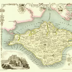
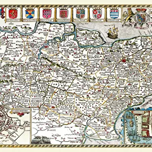
Old County Map of Berkshire 1836 by Thomas Moule

![]()
Wall Art and Photo Gifts from MapSeeker
Old County Map of Berkshire 1836 by Thomas Moule
This is a fine decorative reproduction County Map of Berkshire from the First Edition series of Thomas Moule Maps, originally Published in 1836. The well-known series of County Maps which are known as Moules feature beautiful vignette views and were first published in separate sections for each county in 1830-32, they were then published in collected form in a two-volume work: The English Counties Delineated: or a Topographical Description of England: Illustrated by a Complete Series of County Maps by Thomas Moule: London: Published by George Virtue 1836
Welcome to the Mapseeker Image library and enter an historic gateway to one of the largest on-line collections of Historic Maps, Nostalgic Views, Vista's and Panorama's from a World gone by.
Media ID 20348122
© Mapseeker Publishing Ltd
County Map County Map Of England English County Map Historic Map Moule Map Old County Map Old English County Map Old Moule Map Thomas Moule Thomas Moule Map Berkshire
FEATURES IN THESE COLLECTIONS
> Arts
> Artists
> M
> Thomas Moule
> Europe
> United Kingdom
> England
> Berkshire
> Related Images
> Europe
> United Kingdom
> England
> London
> Towns
> Welling
> Europe
> United Kingdom
> England
> Maps
> Europe
> United Kingdom
> England
> Wells
> Maps and Charts
> Early Maps
> Maps and Charts
> Related Images
> MapSeeker
> Maps from the British Isles
> England and Counties PORTFOLIO
EDITORS COMMENTS
This exquisite print showcases the "Old County Map of Berkshire 1836" by Thomas Moule, a renowned cartographer of his time. Originally published in 1836 as part of Moule's First Edition series, this decorative reproduction captures the beauty and historical significance of the original map. Moule's County Maps are highly regarded for their intricate details and captivating vignette views. Each county was meticulously depicted in separate sections between 1830-32 before being compiled into a two-volume masterpiece titled "The English Counties Delineated: or a Topographical Description of England: Illustrated by a Complete Series of County Maps". This particular edition was published by George Virtue in London in 1836. Berkshire, an enchanting county located in southern England, is brought to life through this historic map. It offers a fascinating glimpse into the past, showcasing the towns, villages, rivers, and landmarks that shaped its rich heritage. The old-world charm exuded by this map makes it an ideal addition to any collection celebrating British history or geography enthusiasts. With its meticulous attention to detail and artistic flair, Thomas Moule's work continues to captivate viewers even centuries later. This print allows us to appreciate his craftsmanship while immersing ourselves in the historical landscape of Berkshire during the early nineteenth century. A true treasure for those who cherish both artistry and history alike.
MADE IN THE USA
Safe Shipping with 30 Day Money Back Guarantee
FREE PERSONALISATION*
We are proud to offer a range of customisation features including Personalised Captions, Color Filters and Picture Zoom Tools
SECURE PAYMENTS
We happily accept a wide range of payment options so you can pay for the things you need in the way that is most convenient for you
* Options may vary by product and licensing agreement. Zoomed Pictures can be adjusted in the Cart.