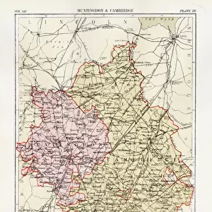
Home > Europe > United Kingdom > England > Huntingdonshire
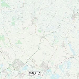
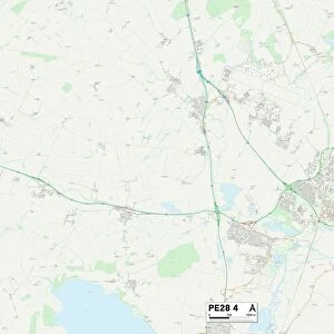
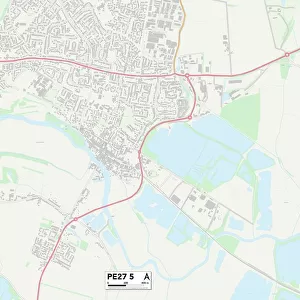
Huntingdonshire PE28 9 Map

![]()
Wall Art and Photo Gifts from Map Marketing
Huntingdonshire PE28 9 Map
Postcode Sector Map of Huntingdonshire PE28 9
Media ID 19976790
Abbots Close Apple Tree Close Bell Lane Brook Side Cambridge Road Chapel Close Chequers Close Cherry Tree Way Church End Church Lane Church Street Common Lane Douglas Close Dove Close Fen Lane Four Acres Glebe Road Green Close Grove End Grove Lane Hampton Close High Street Hilton Hilton Road Home Farm Close Honey Hill Huntingdon Road Huntingdonshire Lea Road Long Lane Low Road Manor Drive Manor Road Marsh Lane Meadow Close Meadow Lane Mill Close Mill Lane Mitchell Close New Road Oakfields Oaklands Orchard Gardens Park Close Pear Tree Close Potton Road Pound Road Priors Road Rookery Way Royal Oak Lane School Lane Scotts Close St Ives Road Swan Gardens Swan Road The Gables The Paddocks Tithe Close Watts Lane Weir Close Weir Road West End Road Willow Court Willow Road Headlands Sallows Stepping Stones
FEATURES IN THESE COLLECTIONS
> Animals
> Birds
> Columbiformes
> Doves
> Related Images
> Animals
> Mammals
> Bovidae
> Goral
> Europe
> United Kingdom
> England
> Cambridge
> Europe
> United Kingdom
> England
> Huntingdonshire
> Europe
> United Kingdom
> England
> Maps
> Europe
> United Kingdom
> England
> Rivers
> Europe
> United Kingdom
> England
> Rutland
> Related Images
> Map Marketing
> Postcode Sector Maps
> PE - Peterborough
> Maps and Charts
> Related Images
MADE IN THE USA
Safe Shipping with 30 Day Money Back Guarantee
FREE PERSONALISATION*
We are proud to offer a range of customisation features including Personalised Captions, Color Filters and Picture Zoom Tools
SECURE PAYMENTS
We happily accept a wide range of payment options so you can pay for the things you need in the way that is most convenient for you
* Options may vary by product and licensing agreement. Zoomed Pictures can be adjusted in the Cart.