Home > Europe > United Kingdom > England > London > Boroughs > Barnet
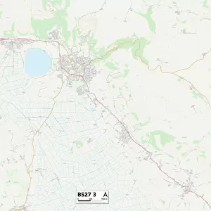
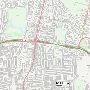
Barnet N20 0 Map

![]()
Wall Art and Photo Gifts from Map Marketing
Barnet N20 0 Map
Postcode Sector Map of Barnet N20 0
Media ID 19976111
Ashbourne Avenue Barnet Bawtry Road Beresford Avenue Britannia Road Bruce Gardens Cameron Close Capel Close Church Close Church Crescent Church Way Darcy Close Denham Road Derwent Crescent Friars Avenue Green Road Greenside Close Gresham Avenue Hayward Road High Road Hobart Close Holden Road Irvine Close Kendal Close Loring Road Manor Drive Marlborough Close Marlborough Gardens Naylor Road Oakleigh Close Orchard Avenue Park Way Pollard Road Queens Avenue Raleigh Drive Russell Gardens Russell Road Sherwood Street St James Avenue St James Close Swan Lane The Mount Turners Close Woodside Avenue Woodside Grove Woodside Lane York Way Baxendale Whetstone
FEATURES IN THESE COLLECTIONS
> Arts
> Artists
> P
> James Pollard
> Europe
> United Kingdom
> England
> London
> Boroughs
> Barnet
> Europe
> United Kingdom
> England
> London
> Sights
> St James Park
> Europe
> United Kingdom
> Scotland
> Strathclyde
> Irvine
> Map Marketing
> Postcode Sector Maps
> N - London N
> Maps and Charts
> Related Images
MADE IN THE USA
Safe Shipping with 30 Day Money Back Guarantee
FREE PERSONALISATION*
We are proud to offer a range of customisation features including Personalised Captions, Color Filters and Picture Zoom Tools
SECURE PAYMENTS
We happily accept a wide range of payment options so you can pay for the things you need in the way that is most convenient for you
* Options may vary by product and licensing agreement. Zoomed Pictures can be adjusted in the Cart.