Home > Europe > France > Paris > Maps
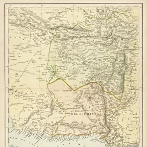
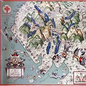
Plan of the Road from the Shutargardan Pass to Cabul, c1880

![]()
Wall Art and Photo Gifts from Heritage Images
Plan of the Road from the Shutargardan Pass to Cabul, c1880
Plan of the Road from the Shutargardan Pass to Cabul, c1880. From British Battles on Land and Sea, Vol. IV, by James Grant. [Cassell Petter & Galpin, London, Paris & Melbourne, c1880]
Heritage Images features heritage image collections
Media ID 14991855
© The Print Collector
1st Earl Roberts Afghanistan Anglo Afghan War Baron Roberts Of Kandahar And Waterford British Battles On Land And Sea Cassell Petter Galpin Earl Roberts Frederick Roberts Frederick Sleigh Grant Imperialism James Grant Kabul Lord Frederick Sleigh Roberts Mountain Pass Petter Galpin Plan Roberts Route Strategy Cassell
FEATURES IN THESE COLLECTIONS
> Arts
> Artists
> R
> James Roberts
> Arts
> Artists
> W
> Robert White
> Arts
> Literature
> Asia
> Afghanistan
> Kabul
> Asia
> Afghanistan
> Kandahar
> Asia
> Afghanistan
> Maps
> Europe
> France
> Canton
> Landes
> Europe
> France
> Paris
> Maps
> Historic
> Battles
> Related Images
> Maps and Charts
> Related Images
EDITORS COMMENTS
This print takes us back to the late 19th century, offering a glimpse into the strategic planning of British military operations in Afghanistan. Titled "Plan of the Road from the Shutargardan Pass to Cabul" this etching is part of James Grant's renowned book, "British Battles on Land and Sea". The image showcases a meticulously detailed map, depicting an important route connecting the Shutargardan Pass to Kabul. The intricate lines and markings reveal a well-thought-out plan for navigating through challenging mountainous terrain. This road served as a crucial lifeline for British forces during the Anglo-Afghan War, highlighting Britain's imperialistic ambitions in that region. The print also introduces us to key figures involved in these military campaigns. Lord Frederick Sleigh Roberts, known as Earl Roberts or Baron Roberts of Kandahar and Waterford, played a significant role in strategizing these operations. His expertise is evident in this comprehensive map. As we observe this historical document, it becomes clear that it represents more than just geography or cartography; it symbolizes power dynamics and political aspirations intertwined with warfare tactics. It serves as a reminder of Britain's presence in Afghanistan during that era. Preserved by The Print Collector29 and published by Cassell Petter & Galpin London, Paris & Melbourne around 1880, this remarkable piece offers us an opportunity to delve into history while appreciating its artistic value.
MADE IN THE USA
Safe Shipping with 30 Day Money Back Guarantee
FREE PERSONALISATION*
We are proud to offer a range of customisation features including Personalised Captions, Color Filters and Picture Zoom Tools
SECURE PAYMENTS
We happily accept a wide range of payment options so you can pay for the things you need in the way that is most convenient for you
* Options may vary by product and licensing agreement. Zoomed Pictures can be adjusted in the Cart.